
 Meteorologists are tracking a push of much cooler and less humid air from Canada.
AccuWeather Global Weather Center – A taste of autumn is in store for the northeastern United States by this weekend, but not before more heat and locally severe thunderstorms roll through some areas through the middle days of this week.
Fans and air conditioners will continue to get a workout into midweek.
While portions of central and northern New England got a break from typical August heat and humidity on Tuesday, conditions remained very much like summer farther south and west through the mid-Atlantic and central Appalachians.
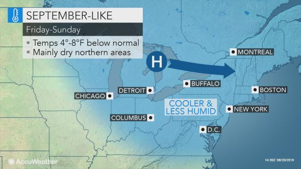
AccuWeather meteorologists are tracking a push of much cooler and less humid air from Canada. That push will spread across the Great Lakes region on Wednesday.
Ahead of the autumnlike air, gusty and severe thunderstorms are forecast over central and eastern New York state and Pennsylvania, and northern and western New England during Wednesday to Wednesday evening.
September-linke
From Thursday to the first part of Friday, a weak storm system is expected to move eastward along the press of cool air. The main effect will be to delay the cooldown and lowering humidity a bit over parts of the Ohio Valley to the Chesapeake and Delaware Bay regions as well as southeastern New England.
As the cooler and less humid air takes root across the North and over the mountains, highs in the upper 70s to the upper 80s F will be replaced with highs in the upper 60s to the upper 70s this weekend. Nighttime lows are forecast to be in the 40s and 50s.
Big changes coming to Northeast following midweek heat, storms added by rctadmin on
View all posts by rctadmin →
You must be logged in to post a comment Login